Yojimbo Scripts on GitHub
My Yojimbo Scripts repository contains a bunch of old scripts (sans documentation, unfortunately) for use with Yojimbo. Most but not all have previously been posted here. I am posting them now as a single collection on GitHub in order to make it easier for others to find and make use of the code.
Posted on Wednesday, August 28th, 2013. Tags: applescript, code, perl, yojimbo.
Finder Scripts on GitHub
My Finder Scripts repository now houses the AppleScripts I wrote for use with the Mac OS X Finder. GitHub provides a better interface for browsing code, managing revisions, and collecting feedback than ad hoc blog posts. In the interest of making my old scripts more accessible to anyone who may find them useful, I intend to re-release them all as open source git repositories.
- LSelect – select files using shell glob syntax (matching against filenames)
- Select Grep – select files using grep (matching against [text] file contents)
- Open As – create and open an explicitly named duplicate of the selected file
Posted on Wednesday, August 28th, 2013. Tags: applescript, code.
Yojimbo to Password Safe
I’ve written a script called yj2pwsafe which adds passwords exported from Yojimbo to Password Safe format database files. Password Safe is an open source password manager developed in part by Bruce Schneier. Many programs are compatible with Password Safe files. My script relies on code from Password Gorilla, a compatible application written in Tcl/Tk.
Downloads, details, and instructions on Github.
I’ve updated yj2pwsafe to be more user-friendly since I first posted this announcement; it is now packaged as an Applescript app that presents a series of dialogs like the one pictured above.
Additionally, I’ve updated yj2pwsafe so that it can import serial number items exported from Yojimbo as well as password items.
Posted on Tuesday, August 20th, 2013. Tags: applescript, tcl, yojimbo.
Gardinator
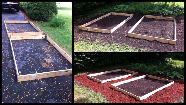
This morning I raked up my fallow back yard garden plot and built a pair of simple raised beds.
I’ve gradually accumulated quite a bit of compost, which I will add to the soil in the beds.
Posted on Tuesday, July 23rd, 2013.
A Limerick, the Throne of the Crescent Moon, and Places in Fiction
Here’s a limerick about Throne of the Crescent Moon, the debut novel by Saladin Ahmed:
There was a wise man from Dhamsawaat
who lived with a boy who prayed and fought.
The man loved an old whore,
who deplored the ghul war,
and the boy met a girl who was not.
(With apologies to Zamia and Raseed for making light of their story – but I suspect Doctor Makhslood would embrace a harmless bit of impious doggerel!)
I enjoy stories with a strong sense of place.
Examples large and small come to mind: sordid New Crobuzon from China Miéville’s Perdido Street Station (not to mention the conjoined cities of The City & The City); Green Town, Illinois – distillate of gothic Americana that it is – from Bradbury’s Something Wicked This Way Comes; all of the burgeoning desert planet Arrakis from Frank Herbert’s Dune; and even Redwall Abbey from the Brian Jacques series of the same name.
Vivid impressions of these places root them in my memory.
I think that in the Crescent Moon Kingdoms – and especially the big, bustling, central city of Dhamsawaat – Ahmed may have created a similarly memorable setting. The main character Aduolla Makhslood is an expert ghul hunter and affable old fart who is all the more relatable for his relation to the places he inhabits: his favorite tea house, his run-down neighborhood, and his own dear home. So, as with the examples above, Aduolla’s world has become a part of mine.
(Links to related short stories…)
Posted on Saturday, July 20th, 2013. Tags: books, limerick, reviews.
Truck Bed Pannier Racks
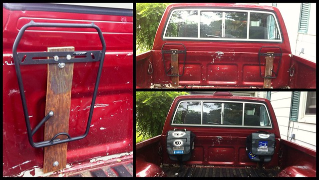
A few weeks ago I put a bike rack in my truck bed. Today I added a pair of pannier racks!
Posted on Saturday, July 13th, 2013. Tags: bike.
Orbits in 3D
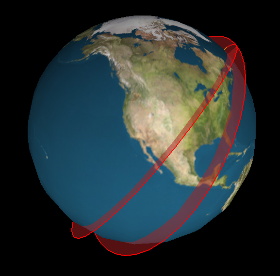
I’ve been playing around with ideas for a new satellite tracking web site. The main idea is to supplement a conventional 2D ground track map (like what I made for Where’s That Sat, or as often seen on the big screen at mission control) with a 3D view that displays the same orbits as paths swept out around the globe. I believe that seeing the actual shape of an orbit in space helps you to interpret the corresponding flat representation. So, there is even an eccentric pedagogic purpose to this project: it is an instructional aid for developing orbital map-reading ability.
Here’s an example:
The code to generate this image is crude, but the results are already encouraging.
Posted on Thursday, July 11th, 2013. Tags: geography.
VXX Report
On Saturday I ran the 43rd annual Vestal XX (20k) road race. My time was 1:35:44, which is better than my rookie result from 2011 (1:36:17), but not as good as last year’s time (1:33:19). I am pleased that I ran consistent splits of 7:45/mile or just under. However, I had hoped to accelerate to a more aggressive pace as the race progressed, similar to my Bridge Run performance. I couldn’t muster the guts. There’s always next year, though, and the year after that, and the year after that… and if you manage to run the Vestal XX twenty times without croaking, you get a special award! A mug.
Posted on Thursday, June 20th, 2013. Tags: running.
Truck Bed Bike Rack
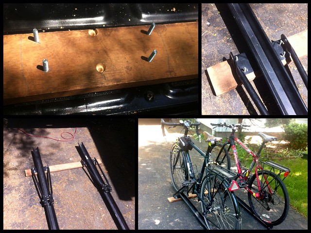
I turned a pair of old roof rack bike trays into a truck bed bike rack. More photos here.
Posted on Thursday, June 20th, 2013. Tags: bike, truck.

