Category Archive: “Uncategorized”
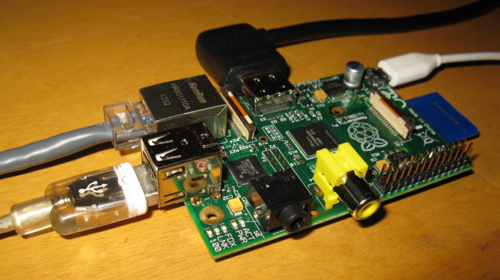
My Raspberry Pi
The Raspberry Pi model B is a 35 dollar computer that’s about the size of a deck of cards.
I believe it is made possible by the proliferation of low-cost components developed for mobile devices like smartphones, which are now adequate to power a modest general-purpose computer. More background and technical details are discussed on Wikipedia.
It’s a bare-bones system consisting of a circuit board ringed with connectors: 2×USB, ethernet, HDMI/RCA video, 3.5mm audio, 5-volt power via micro USB, and an SD card slot. There’s no hard drive; it boots from the SD card, on which I’ve installed Raspbian, a pared-down Linux distribution tailored to the Raspberry Pi. The 5v power supply is common to many cell phones and other small devices. I’m using an iPhone charger.
Eventually I’d like to build a custom case. So far, I’ve just been experimenting with what doodads work with the Pi. It has no built-in wireless networking capabilities, but I was pleasantly surprised to find it readily recognized the little Airlink USB wifi adapter I picked up some time ago (but ultimately did not need) for my laptop.
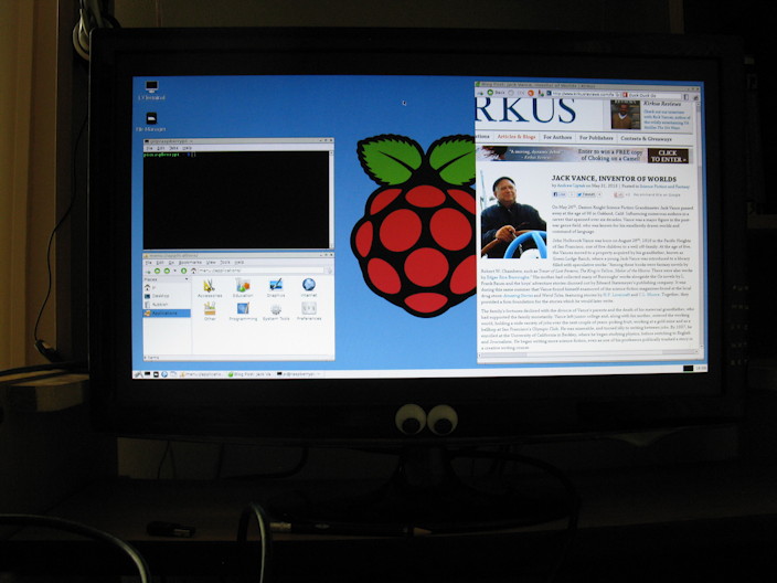
Some tinkering is required to get certain features to work, but the fun of figuring things out is arguably half the point of a device like this. It isn’t very fast, either, but hey, man, it’s only $35!
I haven’t assigned a particular task to my Raspberry Pi yet. Due to its low power consumption and perfectly quiet operation, it seems well-suited to take over from my Mac as a server for my ebook catalog, my growing army of eccentric Twitter bots, or other programming projects. Alternatively, it could be the built-in brain for the book scanner I’m rebuilding. Or it could control a battery-powered 3D helmet-cam!
Posted on Friday, May 31st, 2013. Tags: raspberrypi.
QR9000
Send me a tweet – a URL, for example – and I’ll reply with a QR code representation. The pod bay doors stay closed, though.
— QR9000 (@QR9000) May 4, 2013
I made a Twitter bot named QR9000 that replies to mentions with the text of the tweet encoded as a QR code. Here’s the source code.
QR codes are a machine-readable format for the visual storage of arbitrary information. Evidently they were initially used to tag components on automotive assembly lines; it’s easy to imagine the manufacturing benefits you’d get, in terms of modular tooling, from handling each part as it arrives rather than relying on a pre-programmed sequence.
Today, QR codes are often seen in marketing materials intended to be scanned by people with smartphone apps instead of industrial robots. I am unconvinced that QR codes are better for advertising purposes than old-fashioned human-readable text and images; in many cases, they undoubtedly complicate tasks that should be straightforward.
But, like Cyberdyne Systems, the HAL laboratory at Urbana, Illinois, and innumerable other well-intentioned rogue AI creators, I made the bot anyway. Tweet it a URL and it’ll give you a QR code!
Posted on Monday, May 6th, 2013. Tags: code.
April Denver Austin trip
In April I took a train to visit my sister in Denver, Colorado. Then we drove to Austin, Texas, to attend our cousin’s wedding. Then I took a train back to NY with my mom. Here are a few random snapshots from the trip.
Posted on Monday, May 6th, 2013.
Spring Flowers
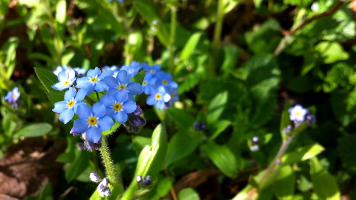
Springtime is marked by the blossoming of many kinds of flowers in my yard. Above, some small blue forget-me-nots. I can’t take credit for planting any of these flowers – that belongs to my mom and grandparents – but I appreciate their colorful presence.
Posted on Monday, May 6th, 2013.
Binghamton Bridge Run
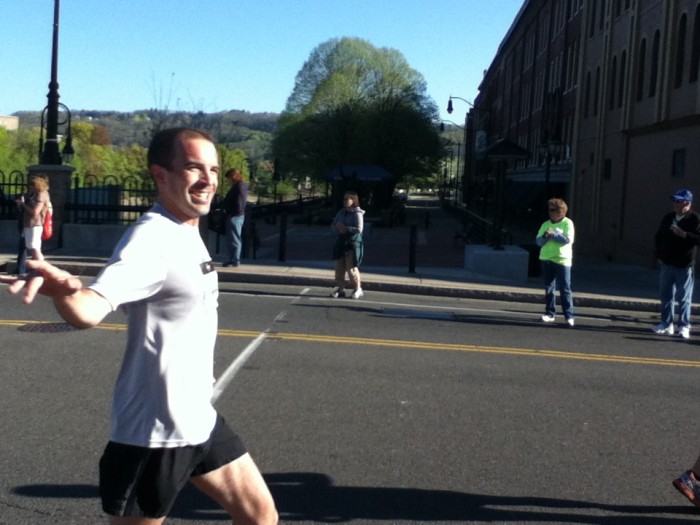
(I was waving to the camera, not flapping my wings like a bird. Photo by mom.)
I ran the Binghamton Bridge Run half marathon this Sunday. Here are the official results: I ran a 1:38:47, and nailed my target average pace of 7:30/mile. My time was about a minute slower than last year’s result (I notice a number of acquaintances’ times were as well), but I ran a much better race this year. I started off relatively relaxed (my early miles were around 7:40 or 7:45) and just gradually increased my pace, staying on the offensive throughout the entire race. It felt very good to remain in an attitude of control the whole way, never lapsing into the psychological state of “just hanging on” – a real risk during the lonelier back half of a long race, in my experience. I hope to carry this confidence into next month’s notoriously hilly Vestal XX.
Posted on Monday, May 6th, 2013. Tags: running.
Running Calendar Update
Instead of running the Uphill Mile race in Ithaca this weekend, I plan to watch the Binghamton Circuit Race and get a couple long runs in in preparation for the Binghamton Bridge Run half marathon next weekend.
Posted on Friday, April 26th, 2013. Tags: running.
One Down
As planned, I ran the Forks XV this past Sunday. It was the 40th running of the race but my first time running it. Here are the official results. I did the 15k in 1:08:30, at an average pace of 7:21 per mile.
Next up is the Remington Murder Mile in Ithaca on April 28. I’ve also added the Oneonta Tuff eNuff Challenge 5k obstacle course to my summer calendar.
Posted on Tuesday, March 26th, 2013. Tags: running.
Fabric Marker Face
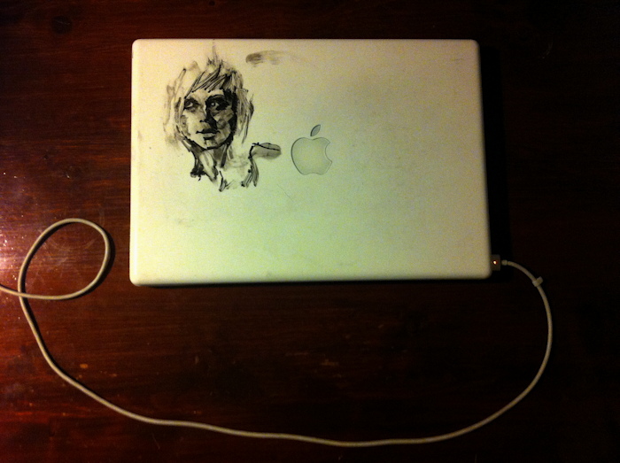
As long-time followers may know, now and then I draw on my old MacBook with markers. Here’s a recent portrait, drawn finger paint style with a fabric marker. The fabric marker ink behaves curiously on this smooth surface – amenable to smudging or scraping erasure, depending whether it’s wet or dry. The mix of textured shading and inky black blots makes this one of my favorite looks in recent memory.
Posted on Friday, March 22nd, 2013. Tags: art, drawing, macbook.
Eclipse Online recipe
I made a Calibre recipe for Eclipse Online, a free short fiction magazine edited by Jonathan Strahan and hosted by Night Shade Books.
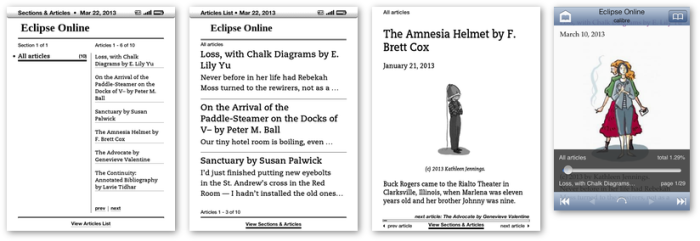
Like Strange Horizons, Eclipse Online is published only as a web site. This recipe assembles an ebook from recent posts and stories. Get more details and the script itself at Github.
Update: Sadly, only a month or so after I discovered Eclipse Online and wrote this recipe, the magazine was closed and will no longer be published.
Posted on Friday, March 22nd, 2013. Tags: books, code, recipe.
2012-2013 Portfolio
Posted on Tuesday, March 19th, 2013.